If you’re reading this that means that you didn’t singe your retinas from staring at the solar eclipse. Congratulations. However, you may have missed what the 2017 solar eclipse truly looked like if you were using the special glasses that had lenses blacked out more than a 114-pound girl after doing shots of Elijah Craig Bourbon on her 21st birthday. Don’t fret. We got you. We gathered the greatest photos of the 2017 solar eclipse for your viewing pleasure and they totally won’t blind you for all eternity.
NASA, which has calculated the time, location and duration of every eclipse up until the year 3000, was busy on Monday and shared some really outstanding photos of the celestial event.
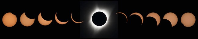
This composite image of eleven pictures shows the progression of a total solar eclipse at Madras High School in Madras, Oregon on Monday, August 21, 2017. A total solar eclipse swept across a narrow portion of the contiguous United States from Lincoln Beach, Oregon to Charleston, South Carolina. A partial solar eclipse was visible across the entire North American continent along with parts of South America, Africa, and Europe. Photo Credit: (NASA/Aubrey Gemignani)
The last glimmer of the sun is seen as the moon makes its final move over the sun during the total solar eclipse on Monday, August 21, 2017 above Madras, Oregon. A total solar eclipse swept across a narrow portion of the contiguous United States from Lincoln Beach, Oregon to Charleston, South Carolina. A partial solar eclipse was visible across the entire North American continent along with parts of South America, Africa, and Europe. Photo Credit: (NASA/Aubrey Gemignani)
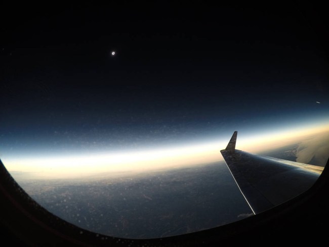
A total solar eclipse is seen on Monday, August 21, 2017 from onboard a NASA Armstrong Flight Research Center’s Gulfstream III 25,000 feet above the Oregon coast. A total solar eclipse swept across a narrow portion of the contiguous United States from Lincoln Beach, Oregon to Charleston, South Carolina. Photo Credit: (NASA/Carla Thomas)
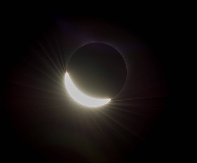
The Sun’s corona, only visible during the total eclipse, is shown as a crown of white flares from the surface during a total solar eclipse on Monday, August 21, 2017 from onboard a NASA Gulfstream III aircraft flying 25,000 feet above the Oregon coast. The red spots called Bailey's beads occurs where the moon grazes by the Sun and the rugged lunar limb topography allows beads of sunlight to shine through in some areas. Photo Credit: (NASA/Carla Thomas)
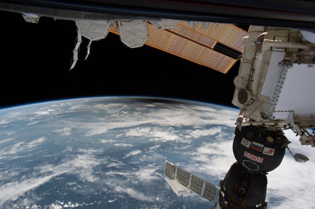
You can see the silhouette of the International Space Station in the light of a solar eclipse.
https://www.instagram.com/p/BYFEWkBDn7i/?taken-by=ingallsimages
Station transits sun at 5 miles per second in video taken at 1,500 frames per second with high-speed camera from Banner, Wyoming. pic.twitter.com/x6NNvCc0Af
— International Space Station (@Space_Station) August 21, 2017
Speaking of the Space Station, here’s what it looked like from the ISS.
You probably saw #SolarEclipse2017 from Earth…but what did it look like from space? Check out these @Space_Station views: pic.twitter.com/6uPdyRFbXs
— NASA (@NASA) August 21, 2017
Voila! The #Eclipse2017 shadow from @Space_Station, no words needed // Voilà! L'eclisse vista dalla Stazione Spaziale, non servono parole… pic.twitter.com/7kD5AYb5zj
— Paolo Nespoli (@astro_paolo) August 21, 2017
The partial solar eclipse from space taken by the European Space Agency’s Proba-2 satellite.
First images of partial #solareclipse from space by our Proba-2 satellite are here! https://t.co/lQBkzdszEj #Eclipse2017 #SolarEclipse2017 pic.twitter.com/QO9TifBhTt
— ESA Science (@esascience) August 21, 2017
More photos from the ESA.
And from shortly after totality by #CesarEclipse17 team. https://t.co/20xbNo0BV4 #SolarEclipse2017 #Eclipse2017 pic.twitter.com/7XnX9FpKDa
— ESA Science (@esascience) August 21, 2017
#CesarEclipse17 images running again, playing catch up! Beautiful image from totality https://t.co/20xbNoicMC #SolarEclipse2017 #Eclipse2017 pic.twitter.com/5GZfLCfmma
— ESA Science (@esascience) August 21, 2017
Check out the partial solar eclipse over Ross Lake, in Northern Cascades National Park, Washington.
https://www.instagram.com/p/BYFFD1xDkaN/?taken-by=ingallsimages
The eclipse as seen at the Arthur Ravenel Jr. Bridge in Charleston, South Carolina.
INCREDIBLE: A solar eclipse shows through a layer of clouds over the Ravenel Bridge in Charleston, S.C. pic.twitter.com/tgahazqEog
— Fox News (@FoxNews) August 22, 2017
This photo taken at Smith Rock State Park in Oregon is outstanding.
You can check out how the solar eclipse looked like from NOAA Satellites as it brought large swathes of the United States into darkness.