Getty Image
Astronauts, space stations, and NASA have been sharing photos of how the California wildfires look from outer space. What they reveal is just how immense the size of the devastation is in and around Los Angeles and Ventura counties.
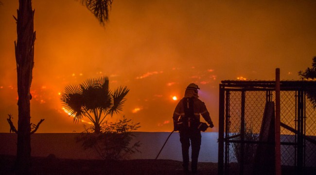
CNN reports that, as of today, six wildfires in California have burned nearly 160,000 acres and have forced 190,000 people out of their homes. More than 5,700 firefighters are currently involved in trying to contain the blazes.
Reuters reports at least 500 structures have been destroyed by the fires and 86,000 homes could be destroyed in Ventura and Los Angeles counties. At the current rate of destruction, CoreLogic CLGX.O, a New Jersey-based risk analysis firm, reconstruction could possibly total $27.7 billion.
https://www.instagram.com/p/BcYgCbJgvTj/?tagged=california
On Friday, President Trump issued a federal emergency declaration for the state of California, which allows FEMA and Homeland Security to institute relief efforts.
To put the size of the damage being caused by these wildfires in perspective, here are some of the photos that the astronauts, space stations and NASA have been sharing over the past couple of days.
I was asked this evening if we can see the SoCal fires from space. Yes Faith, unfortunately we can. May the Santa Ana’s die down soon. #Californiawildfire pic.twitter.com/qNzjTjWa4t
— Randy Bresnik (@AstroKomrade) December 6, 2017
Thank you to all the first responders, firefighters, and citizens willing to help fight these California wildfires. #CaliforniaWildfires pic.twitter.com/TyeGx4z85Q
— Randy Bresnik (@AstroKomrade) December 7, 2017
Today’s pass over SoCal unfortunately doesn’t look any better. The fires east of Camp Pendleton and in Baja are visible as well. #CaliforniaWildfires pic.twitter.com/khM9TK1u0F
— Randy Bresnik (@AstroKomrade) December 7, 2017
#Fires in Southern #California…The smoke plume from the California wildfires as seen from the International Space Station. pic.twitter.com/sP40CO3tIl
— Сергей Рязанский (@SergeyISS) December 7, 2017
Some new photos of forest #fires in Southern #California… pic.twitter.com/fb8qKZE2Sj
— Сергей Рязанский (@SergeyISS) December 8, 2017
During an engineering flight test of the Cloud-Aerosol Multi-Angle Lidar (CAMAL) instrument, a view from @NASAArmstrong's ER-2 shows smoke plumes, from roughly 65,000 feet, produced by the #ThomasFire , around 1 p.m. PDT on December 5th, 2017. Photo Credit: Stu Broce pic.twitter.com/c6El8F0HJN
— NASA Armstrong (@NASAArmstrong) December 6, 2017
Burn scars and active fires in Ventura County, CA are visible in this false-color view created using data from @ESA’s Sentinel-2 satellite on Dec. 5. Active fires appear orange, while burn scars are brown. Find out more: https://t.co/MXKj2lLIPi pic.twitter.com/g7OHGAvqTd
— NASA (@NASA) December 7, 2017
Fires continue sweeping across Southern California amid strong Santa Ana winds. Here's a new look at the smoke plumes from one of our @NASAEarth satellites: https://t.co/jfcyXFg1np pic.twitter.com/P6jolrC1sE
— NASA (@NASA) December 7, 2017
Data & imagery of the California wildfires from our satellites, people in space and aircraft, not only give us a better view of the activity, but also help 1st responders plan their course of action. Get the details: https://t.co/BN9dmPiXep pic.twitter.com/82MQ3mU521
— NASA (@NASA) December 7, 2017
Copious columns of gray-brown smoke pour off the edge of California's coast in this image of wildfires taken by our @NASAEarth satellites on December 7: https://t.co/gnZxhGy3s3 pic.twitter.com/JvYBaPlEj0
— NASA (@NASA) December 8, 2017
And here’s an image one Twitter user made showing the locations of the various cities being affected in California.
https://twitter.com/mrlevine/status/938959010816057344
Our thoughts are with everyone being affected by this monumental disaster. Be safe, everyone.
H/T Distractify