NASA
Hurricane Irma strengthened to a catastrophic Category 5 storm and poses a threat to the United States. The storm’s maximum wind speeds are 175 mph, making it one of the most powerful hurricanes ever recorded in the Atlantic Ocean. Hurricane warnings have already been issued for many islands in the Caribbean including the Leeward Islands and the Greater Antilles, as well as Puerto Rico. Currently, the storm surge is expected to be 6-feet and rain totals as high as 10 inches in the Leeward Islands. Irma is moving west at 14 mph and expected to smash into islands such as Antigua, Barbuda, and Saint Martin on Tuesday, then hit Puerto Rico and the Dominican Republic before barreling to Cuba and the Bahamas. Southern Florida and the Florida Keys could be in Irma’s destructive path as early as Sunday.
8 am Special Advisory: #Irma is now a category 5 #hurricane with maximum sustained winds of 175 mph (280 km/h) More: https://t.co/tW4KeGdBFb pic.twitter.com/QU1LWq7QsA
— National Hurricane Center (@NHC_Atlantic) September 5, 2017
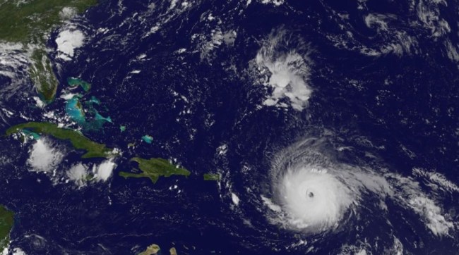
The eye of a category 5 hurricane. #Irma #GOES16 pic.twitter.com/eATVZspJZx
— NASA SPoRT (@NASA_SPoRT) September 5, 2017
#Irma has that 'buzzsaw' look en route to the northern Leeward Islands today … devastating impacts. pic.twitter.com/CLBQ4pgJtx
— Ben Noll (@BenNollWeather) September 5, 2017
First light over the Atlantic reveals the stunning category 5 Hurricane #Irma. Irma & Matthew the only 2 Atlantic cat 5's in last decade. pic.twitter.com/pZj6h0JF13
— Ben Noll (@BenNollWeather) September 5, 2017
Hurricane Irma is now a category 5. Watch The Weather Channel now for Live Coverage and the latest track for Florida. pic.twitter.com/MisnIKwJS7
— The Weather Channel (@weatherchannel) September 5, 2017
“Preparations should be rushed to completion in the hurricane warning area,” the National Hurricane Center said on Tuesday morning. The NHC called Hurricane Irma an “extremely dangerous” storm. On the Saffir-Simpson Hurricane Wind Scale, a Category 5 hurricane features winds of 157 mph or higher, “catastrophic damage will occur: A high percentage of framed homes will be destroyed, with total roof failure and wall collapse. Fallen trees and power poles will isolate residential areas. Power outages will last for weeks to possibly months. Most of the area will be uninhabitable for weeks or months.”
11pm AST forecast on #Irma. Hurricane Warning issued for Puerto Rico and the U.S. and British Virgin Islands. https://t.co/sYVOB3gkmI pic.twitter.com/GhwwXJCwym
— National Hurricane Center (@NHC_Atlantic) September 5, 2017
Hurricane Irma strengthens in the Atlantic sparking alarm in Caribbean, Florida, which are in the path of the storm https://t.co/sY3iu9KL0K pic.twitter.com/udusecRlXG
— AFP News Agency (@AFP) September 5, 2017
https://twitter.com/RyanMaue/status/905062000623067136
Hurricane #Irma now a category 5 and it's a beast. It's larger than the state of Ohio, if that helps put it in perspective. pic.twitter.com/JtoZNlONeE
— ⚡JD Rudd ☈ (@jdrudd) September 5, 2017
Amazing stadium effect seen by #GOES16 on Category 5 hurricane #Irma. pic.twitter.com/TooUklx847
— Matt Miziorko (@SnarkyEM) September 5, 2017
Florida Governor Rick Scott declared a state of emergency for Florida on Monday to give local governments enough “time, resources and flexibility to get prepared for this dangerous storm.” Scott also said, “Hurricane Irma is a major and life-threatening storm, and Florida must be prepared. In Florida, we always prepare for the worst and hope for the best,” Scott said, “and while the exact path of Irma is not absolutely known at this time, we cannot afford to not be prepared.” Puerto Rico has also declared a state of emergency and activated the National Guard. The director of Puerto Rico’s power company predicted that storm damage could leave some areas of the island without electricity for four to six months.
Just spoke to @POTUS – he offered the full resources of the federal government as Floridians prepare for Hurricane Irma.
— Rick Scott (@SenRickScott) September 5, 2017
https://twitter.com/CaitlinMcGehee/status/905071772244082688
Getting very concerned about track for #Irma. Spaghetti plots showing model clustering for a S FLA hit as a powerful hurricane Sun am. pic.twitter.com/CBfd2Oz6RR
— Mark Robinson (@StormhunterTWN) September 5, 2017
https://twitter.com/RyanMaue/status/904927393525182464
Irma becomes the 17th Atlantic Ocean hurricane on record to have 175 mph winds. The record for maximum wind speed in the Atlantic is held by Allen at 190 mph in 1980. And only five hurricanes in the satellite era (since 1966) have hit the Leeward Islands with max winds of 140 mph or more David (1979), Hugo (1989), Luis (1995), Lenny (1999), and soon to be Irma.
How strong is #Irma? Its current intensity of 175 mph is the same as Hurricane Katrina (2005) at its max intensity. pic.twitter.com/H6ZcLjL8hT
— Philip Klotzbach (@philklotzbach) September 5, 2017
#Irma has now generated more Accumulated Cyclone Energy during her lifetime than did Hurricane Katrina (2005). pic.twitter.com/Vl8D3qpwAX
— Philip Klotzbach (@philklotzbach) September 5, 2017
https://twitter.com/jonesdesign1/status/904985078715092993
The hurricane hunters of the National Oceanic and Atmospheric Administration flew right into Hurricane Irma.
Ride along with WP-3D Orion #NOAA42 for the first flight through #HurricaneIrma. Flights continue today. Credit LT Rob Mitchell/NOAA pic.twitter.com/7sjigdNiv7
— NOAA Aircraft Operations Center (@NOAA_HurrHunter) September 4, 2017