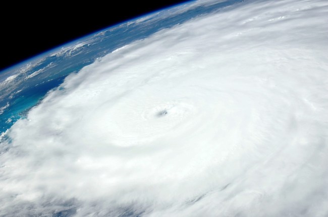
Hurricane Laura is expected to make landfall as a Category 4 in parts of Texas and Louisiana late Wednesday night or early Thursday morning and the National Weather Service issued a rather horrifying update on Wednesday afternoon. According to the NWS, the hurricane is expected to produce an ‘unsurvivable storm surge with large, destructive waves’ that could penetrate up to 30 miles inland.
There isn’t a scarier adjective that could be used than ‘unsurvivable’ when speaking about a storm. The NWS’ peak storm surge graphic also shows areas that could see a peak storm surge of 15 to 20 feet above dry land.
Unsurvivable storm surge with large, destructive waves will cause catastrophic damage from Sea Rim State Park, TX, to Intracoastal City, LA. Surge could penetrate up to 30 miles inland.
If you need to evacuate, do so NOW. Surge will begin today, well ahead of the strongest winds pic.twitter.com/H6ZgRAiJ14
— National Weather Service (@NWS) August 26, 2020
As best I can tell, the National Weather Service has never used the phrase “unsurvivable storm surge” before—at least not on its twitter account or any web product. https://t.co/RfTYJ8QB0b
— southpaw (@nycsouthpaw) August 26, 2020
According to The Washington Post, more than a half-million people were ordered to evacuate coastal areas in Texas and Louisiana, where seas were beginning to build on Wednesday.
Hurricane Laura was a Category 1 early Tuesday but has since jumped to a Category 3 and is expected to move to a Category 4. The peak winds moved from 75 mph to 125 mph in a span of just 24 hours with its rate of intensification being the largest seen since Hurrican Irma in 2017.
CIRA captured this unbelievable video of lightning striking in the middle of the ginormous storm expected to make landfall soon.
Lightning flashes within the outer bands of Hurricane Laura. pic.twitter.com/2dldh4HRPC
— CIRA (@CIRA_CSU) August 26, 2020
Port Arthur, TX is expected to be impacted by the storm and was under mandatory evacuation. It is home to the United States’ largest oil refinery.