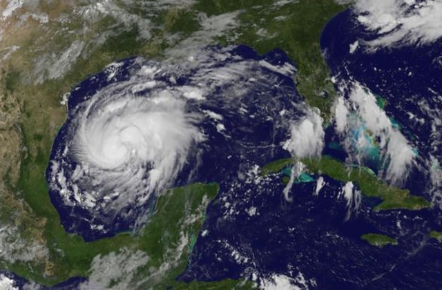
Tropical Storm Harvey has been upgraded to a Category 1 hurricane (74–95 mph) as it bears down on Texas. Harvey has shown no signs of weakening as it prepares to pound the coast of Texas. The hurricane has gathered strength and moisture while in the Gulf of Mexico and Harvey is projected to make landfall on the Texas coast on Friday night as a Category 2 (96–110 mph) or 3 (111–129 mph) hurricane.
#Hurricane Harvey with 85 mph winds as of 7 PM CDT, still expected to become CAT 3 major hurricane before landfall along TX coast early Sat. pic.twitter.com/bPu0HiWWfM
— National Hurricane Center (@NHC_Atlantic) August 25, 2017
People in #Texas should prepare today for #Hurricane #Harvey as winds could be too strong for preparations on Friday https://t.co/tW4KeGdBFb pic.twitter.com/uEOgdtDnQD
— National Hurricane Center (@NHC_Atlantic) August 24, 2017
The last hurricane to make landfall in Texas was Ike as a Category 2 on Sept. 13, 2008. Some are even saying Harvey could become a cataclysmic category 4 (130–156 mph) hurricane by the time it smashes into Texas.
https://twitter.com/RyanMaue/status/900736150901587968
Intensity guidance for #Harvey continues to climb. Category 3 certainly seems attainable, Category 4 (130mph+) not out of the question. pic.twitter.com/1pm0raz4OE
— Eric Fisher (@ericfisher) August 24, 2017
Hurricane Harvey will make landfall near Corpus Christi Texas as a category 3 or 4 hurricane tomorrow night #kswx pic.twitter.com/Yy726BTaHH
— NWS Dodge City (@NWSDodgeCity) August 24, 2017
There is expected to 10 to 35 inches of rain to fall and saturating Texas. There is significant flash flooding possible as Harvey makes landfall and stalls over the state for several days through the weekend into early Monday. The widespread flooding will wreak havoc on streets, highways, bayous, streams, and rivers.
Up to 35 inches of rain possible over SE #Texas through Wed & could cause life-threatening flash flooding https://t.co/tW4KeGdBFb #Harvey pic.twitter.com/qak9ob9WE6
— National Hurricane Center (@NHC_Atlantic) August 24, 2017
Here's why some areas in southeast Texas could get up to 3 FEET of rain. #Harvey lingers well into next week! pic.twitter.com/6odc7i9fsC
— Ed Piotrowski (@EdPiotrowski) August 24, 2017
There will be dangerous surf, beach erosion, and damaging winds. The most deadly attribute of the hurricane could be the massive storm surge that pushes a wall of water at the shore.
As #Harvey nears TX, @Ginger_Zee explains science behind storm surge, greatest threat to life, property in hurricane https://t.co/u43dQJPmwA pic.twitter.com/ayci9lqWB4
— ABC News (@ABC) August 24, 2017
Dr. Rick Knabb, hurricane expert at The Weather Channel, said of Harvey, “In all these years, it’s rare that I’ve seen a hurricane threat that concerns me as much as this one does.”
.@DrRickKnabb has an important message for anyone in the path of #HurricaneHarvey. pic.twitter.com/CKUTOR3Rr9
— We Love Weather (@WeLoveWeather) August 24, 2017
A state of disaster was declared for 30 counties in Texas by Harvey by Gov. Greg Abbott ahead of the massive storm.
Video shows Tropical Storm #Harvey strengthening in Gulf; expected to become a Cat 3 hurricane as it approaches TX. https://t.co/rWCvSWJFQt pic.twitter.com/xqZw4GWcaU
— ABC News (@ABC) August 24, 2017
“Impacts from Harvey will be tremendous in terms of displacement of people, property and economic loss and travel and freight disruptions,” according to AccuWeather Vice President of Forecasting and Graphics Operations Marshall Moss.
30-second imagery of rapidly intensifying Hurricane #Harvey from GOES-16. pic.twitter.com/b8CFxJdgQD
— NWS Eastern Region (@NWSEastern) August 24, 2017
The mayor of Corpus Christi told residents in low-lying areas to “get out of dodge.”
Corpus Christi mayor advises residents in low-lying areas to "get out of dodge" ahead of Hurricane Harvey's landfall https://t.co/Gdj5Pm722n
— NBC News (@NBCNews) August 24, 2017
Gas station pumps could go down, power outages could last days as crews struggle to get to all communities because of down powerlines and trees. Please adhere to all warnings and leave dangerous areas if you are instructed to before you are unable to.