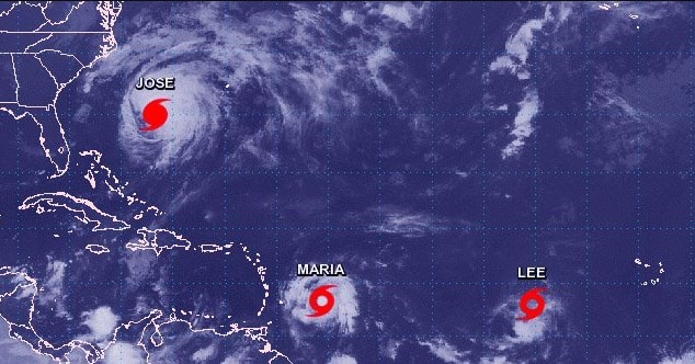
The Caribbean and parts of the United States is still trying to recuperate and rebound from the devastating effects of Hurricane Harvey and Hurricane Irma. There are actually three storms in the Atlantic Ocean right now with Hurricane Jose, Hurricane Maria, and Tropical Storm Lee.
Here are the latest NHC track maps for #Jose, #Lee, and #Maria. None are a threat to the Gulf for the next several days #txwx pic.twitter.com/Ld6zuIZ5Ng
— NWS Houston (@NWSHouston) September 17, 2017
Islands in the Caribbean and certain locations in Florida were demolished by Hurricane Irma, not they are being threatened by Hurricane Maria. Look at how close the paths are for both Hurricane Irma and Hurricane Maria.
Just how closely will #Maria's track match #Irma's? Check the disturbing new forecast. pic.twitter.com/jXBCxSdTnI
— CNN Weather Center (@CNNweather) September 18, 2017
Only 3 times before have 2 #hurricanes tracked w/in 75 mi. of the Virgin Isl. in the same season: 1999, 1916, 1852. Never 2 Cat 3+. #Maria pic.twitter.com/7hT75N6SA8
— Jonathan Erdman (@wxjerdman) September 17, 2017
Hurricane Maria is now a Category 1 hurricane with 80 mph winds that could unleash “a dangerous storm surge accompanied by large and destructive waves.” The eye of Hurricane Maria was expected to hit the Leeward Islands within 48 to 72 hours and then move toward Puerto Rico in four days where it could develop into a Category 3 hurricane with 125 mph winds. Hurricane watches have been issued for Antigua, Barbuda, St. Kitts, Nevis and Montserrat, Guadeloupe, Saba and St. Eustatius, St. Maarten, Dominica, and Anguilla. Tropical storm watches are posted for St. Lucia, Martinique, Barbados and St. Vincent, and the Grenadines.
Tropical Storm Maria is forecast to become a hurricane later today. Impacts are likely for the U.S. Virgin Islands and Puerto Rico. pic.twitter.com/uXpSsjAufB
— National Weather Service (@NWS) September 17, 2017
https://twitter.com/RyanMaue/status/909600000396718082
[protected-iframe id=”38aa4be7158bddfed56052c87e6b46fe-97886205-93291949″ info=”//static.apester.com/js/sdk/v2.0/apester-javascript-sdk.min.js” height=”600″ class=”apester-media”]
Hurricane Jose is slowly approaching the Northeast. And while it has a small percentage of making landfall, it is expected to hit the coast with powerful swells, life-threatening rip currents, tropical storm-force winds, and heavy rain.
NHC odds of Tropical Storm conditions from #Jose:
DC: 10%
Philly: 22%
Atlantic City: 34%
NYC: 35%
Nantucket: 60%
Boston: 34%
Halifax: 6% pic.twitter.com/5UUTujdNOm— Eric Holthaus (@EricHolthaus) September 17, 2017
#Jose yielding rough surf & higher than average tides. Dune & sandbags in place to stop the water @MartellsTikiBar in Pt. Pleasant Beach NJ. pic.twitter.com/KawpYboSZa
— Mike Seidel (@mikeseidel) September 17, 2017
BREAKING: Hurricane #Jose triggers a tropical storm watch for the mid-Atlantic and New England coasts: https://t.co/o9cSTl64QN pic.twitter.com/rmwT5tTYUj
— The Weather Channel (@weatherchannel) September 17, 2017
Tropical storm watch now up for #Jose from Delaware to SE Massachusetts- read the new advisory at https://t.co/JuoyWO37BI pic.twitter.com/kzOq09Frn5
— Eric Blake 🌀 (@EricBlake12) September 17, 2017
Tropical Storm Lee formed on Saturday in the eastern Atlantic Ocean and is approximately 700 miles southwest of Cape Verde off northwest Africa with maximum sustained winds of 40 mph. Thankfully, Lee is weakening and is expected to be downgraded to a depression on Tuesday. No land warnings have been issued.
Oh, and by the way, Tropical Storm Otis has formed in the Pacific Ocean.
While the focus is on #Jose & #Maria– #Otis in the east Pacific pops an eye after taking 5 days to become a tropical storm- unbelievable 🙄 pic.twitter.com/DMiTSSIizk
— Eric Blake 🌀 (@EricBlake12) September 17, 2017