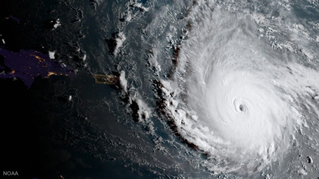
NOAA
Hurricane Irma weaved a path of ferocious destruction as it plowed through the Caribbean. At 2 a.m. on September 6, the eye of the then mighty Category 5 Hurricane Irma with winds of up to 185 mph ripped the tiny island of Barbuda to shreds. Leaving a path of devastation in its wake that is said to have destroyed 90% of structures on Barbuda. Starting with the Leeward Islands, Hurricane Irma obliterated island by island in the Caribbean as it made its way to Florida. When it was all said and done, nearly 40 people were dead and tens of billions of dollars in damage was accumulated, and possibly as much as $200 billion. Buildings, airports, harbors, were all severely impacted by the cataclysmic storm.
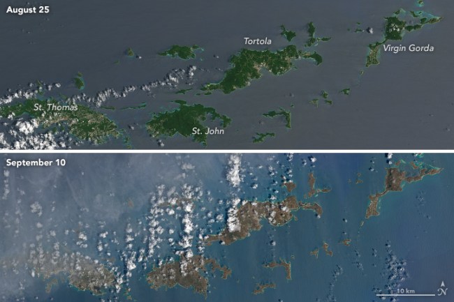
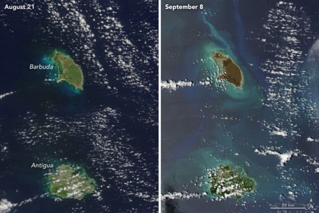
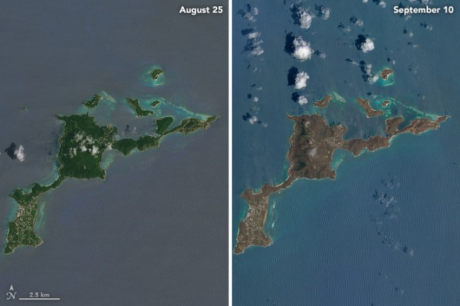
Before and after satellite images reveal all of the ruin and devastation that Hurricane Irma inflicted on the Caribbean and Florida. You may notice that the once lush and green islands are now brownish. Tree and vegetation were ripped from the ground as well as the salt water sprayed by Hurricane Irma coated and desiccated leaves of plants and trees. The destruction is so severe that you can see islands actually changed from the hurricane in these unbelievable photos from space.
Caribbean
https://twitter.com/Breaking911/status/907369567281967104
Powerful footage shows the devastation caused by #HurricaneIrma
| Before & After #Irma 🌪 | pic.twitter.com/PEZPWPkXPN
— Thirukumaran R (@ThiruHR) September 9, 2017
Barbuda
[protected-iframe id=”38aa4be7158bddfed56052c87e6b46fe-97886205-93291949″ info=”//static.apester.com/js/sdk/v2.0/apester-javascript-sdk.min.js” height=”600″ class=”apester-media”]
Virgin Gorda
Saint Martin
So sad for SXM.
Here's a crude before/after #Irma using Google maps. pic.twitter.com/rPhYdCx7jR— Chris Chmura ✈ (@Chris_Chmura) September 7, 2017
Tortola
Last week, Irma's eye grazed the island of Tortola, practically leveling the capital, Road Town. More before/after: https://t.co/Eg6wN6En9K pic.twitter.com/pmHQ9HWkMu
— Post Graphics (@PostGraphics) September 11, 2017
The Most Soul-Crushing Photos And Videos Of Devastation From Hurricane Irma So Far
Turks and Caicos
https://twitter.com/Breaking911/status/906997430750773249
Before/after #Irma shot of S Florida. Note all the sediment stirred up in the shallow waters! MODIS imagery from https://t.co/vaXfaCS4UV pic.twitter.com/yTCw58blka
— NWS Caribou (@NWSCaribou) September 11, 2017
..before & after strom surge #Miami #Irma #Florida via @TWCAlexWallace pic.twitter.com/b4yEez9cVi
— Miami Beach Pages (@MiamiBeachPages) September 10, 2017
[NASA]